| The
truth can now be told. Embedded in our nation's road sign system is a
secret coding designed to target vital sites, facilities, routes and
resources for military confiscation during a National Emergency. Though,
concealed by the lies of the Department of Transportation for many
years, "Free Indeed Research" has tapped deeply into one of the most
clever, and deceptive cover-up operations to come down the pike in
years! (If you think GPS will be working normally in the scenario described herein, think again.) The United Nations military has plans to become the cop soldiers of the world. Unknown to the general populace, a "Rapid Deployment" force stands ready to enter U.S. borders at the request of the President of the United States during a national emergency. They will perform "peacekeeping" operations such as evacuations, rounding up dissenters, confiscating firearms and incuring facilities and sites for military use. These forces are laced with foreign troops that do not speak english. Therefore, as a tactical advance, all nations have been secretly revamping their roads sign systems to conform to an international standard under the guise of the WTO. It is our belief that these signs and reflective markers "TACMARS" on the backs of many signs are coded to target vital sites, facilities and resources to be confiscated and used by these troops.  *TACMARS* pointing to a "RITE AID" pharmacy with "ONE HOUR" passport, photo ID; drive-thru window with scanners, inoculation center to vaccinate populace.  Triad (3) markers on the back of blue signs denoting a blue route leading to empty housing units at a large ski resort. Triad (3) markers on the back of blue signs denoting a blue route leading to empty housing units at a large ski resort. Sign cluster at access road to the gymnasium of Lake City high school, Lake City, MI 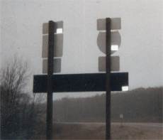 Sign cluster with triad"tacmarks" found just prior to Camp Grayling Military Reserve *checkpoint*. Sign cluster with triad"tacmarks" found just prior to Camp Grayling Military Reserve *checkpoint*."For many years now, under the guidance of federal and local managers, every city, town and village in the U.S. has been covertly set up by manipulating and using our sign system to target and mark vital sites, facilities and resources for confiscation and seizure by the military."
"NAVAL CHIEF PETTY OFFICER TESTIFYS OF *TACMARS* DURING TOUR OF DUTY IN MIDDLE EAST!
'While I was stationed in Beirut, Lebanon after the bombing in the 80's, I saw those markers (tacmars) put on the back of their roadsigns to bridge language barriers among multinational peacekeepers doing military operations in the city.' (CPO A.Phillips U.S.N.) We have hundreds of sign code patterns in photo form that confirm the configurations are not just random positionings, but are altogether part of a clever directional code system called "TACKAMARKS", or "TACMARS" ("tactical markers") a code system for military use. NEW! "Catastrophic worldwide weather chaos a warning something is up; FEMA drills cause mistake to evacuate Connecticut. If nothing else, this proves FEMA has evacuation plans in place to relocate populations, even entire states. Keep an eye on this one. "FEMA Preparing for Mass Destruction Attacks on Cities". "The agency plans to create emergency, makeshift cities that could house hundreds of thousands, if not millions, of Americans who may have to flee their urban homes if their cities are attacked." -"FEMA is currently seeking bids from major real estate management firms, and plans to name three firms in the near future to handle the logistics and planning for these temporary cities." -"FEMA officials have told these firms they already have tents and trailers ordered. The tents and trailers would provide shelter for displaced populations." NewsMax 

Staging areas for "Temporary City" with semi-trailers, marked by signcode markers. (Complete with water, sewer, and electric)
(The
truth is coming out folks--are you prepared to be relocated? Don't be
fooled, these plans have been in the works long before "911".)
Bush Plan: Military Enforced Quarantines for U.S. Civilians "Among the specific proposals are plans to allow soldiers to enforce quarantines in the event of a chemical or biological weapons attack and the creation of "red teams"..." FOX NEWS DANGER! FORCED INOCULATIONS WILL KILL U.S. CITIZENS! "All mass vaccination campaigns result in casualties.." "There are legitimate concerns about a plan which forces citizens to use vaccines without their voluntary, informed consent." National Vaccine Info Center OMINOUS SIGN CODES AT GRAVEL PITS AND LANDFILLS. Mass graves, cremations and burial sites marked for bio/chem infected dead, the ultimate FEMA relocation plan, 'We will bury you.' ROCKY MOUNTAIN NEWS 
Bioterror
confronts us with the unthinkable. Located at the outskirts of the
cities and towns are found TACMARS marking land-fills, pits, cemetaries,
and quarries slated for "cleanup" operations as mass graves for the
perished.
"CAMPS FOR U.S. CITIZENS: ASHCROFT'S HELLISH VISION""Atty. Gen. John Ashcroft's announced desire for camps for U.S. citizens he deems to be "enemy combatants" has moved him from merely being a political embarrassment to being a constitutional menace." "BLACKOUT BOMB" the bomb the government doesn't want to talk about. -"A megaton-class, thermonuclear explosion about 250 miles over Omaha, Nebraska, would emit an Electromagnetic Pulse large enough and strong enough to collapse information society from coast to coast at the speed of light." -"The Blackout Bomb means that we are vulnerable to complete information civilization shutdown, and there is nothing we can do about that in a military defensive sense." -"Satellites are especially vulnerable to the x-rays and gamma rays from a high-altitude nuclear explosion, which is different from atmospheric EMP but radiated spherically around the explosion. No United States satellites, he added, can be considered reliably protected from space EMP, because EMP testing of protective systems is erratic." (Goodbye GPS satellites! Those TACMARS and signcodes may just come in handy, especially at night when the power goes off.)
Secretly embedded codes like these are part of "Operation Garden Plot" where U.S. forces/National Guard and *Partnership* NATO/UN
military will police and patrol our streets and highways during MARTIAL
LAW. Detention areas, and facilities with massive air-lifts are planned
to relocate the populace to "safe zones" during a bio/chem or nuclear
attack.
SAMPLE ID CARDS
*HOMELAND SECURITY* "CHECKPOINTS""CITIZEN, CAN I SEE YOUR ID?"
THE FOLLOWING INFORMATION AND LINKS ARE FOR THE SKEPTICS WHO ARE IN DENIAL:
FEMA EVACUATION SIGNS!

"ARROW-UP"
signs with a secondary meaning? Hmm... our critics say this is
"hogwash"! Sometimes being right is just not enough. Here's the proof
straight from the mouth of the D.O.T.; secret *staging areas*, emergency
*landing zones*, operational sites, and routes, all hidden from the
public. And you thought we were making this all up!
D.C. EVACUATION ROUTE MAP"Officials released the map after deleting sensitive information about staging areas, emergency landing zones, operations headquarters and internal transportation routes designated for use by federal and local authorities in the event of a biological, chemical or nuclear attack." Washington Post but with "sensitive areas" deleted. "Strategic Highway Network"
The
above link is for the critic who talks a lot but knows nothing. This
website reveals that roads were purposely constructed for military rapid
deployment and "lead" to vital sites. (Hitler's "AUTOBAHN" Highways) In this case, more DOT information about the purpose, design and reasons for our highway system.
"National Highway System" or NHS. "It is approximately 160,000 miles (256,000 kilometers) of roadway important to the nation's economy, defense, and mobility."
"Other Principal Arterials: These are highways in rural and urban areas which provide access between an arterial and a major port, airport, public transportation facility, or other intermodal transportation facility." 
Transportation facility (school bus center)off arterial M-72 marked by *arrow-up* international/european signcodes.
 Signcodes on arterial M-72, marking turn to above transportation facility. (click photo to view *tacmars* on the back of this sign array.) "Al-Qaida training manual shows seaports as top targets."(Could UN "tacmars" be marking targets for terrorists?)
U.S. Strategic Highway Network (STRAHNET)
"STRAHNET roadways are those which would be used for the rapid mobilization and deployment of armed forces in the event of war or peacekeeping activity." (Global Security.org)
NEW! "TACMAR" SIGN CODES IN CANADA! "Dangerous goods" routes in Alberta, Canada lead to detention areas with tops-in barbed wire and tacmar codes". (Stephen Volk)
You are visitor #      
This website is dedicated to late author and research investigator JIM KEITH who
first published some of the early stages of our research in his sequel
"Black Helicopters II The Endgame Strategy". (see chapter 12 "Vital
Signs-The Quadrant Sign Code") Thank you Jim for the encouragements to
get this site going--we greatly miss you.

Target site on a blue route, DNR "CCC" Conference Center/Campground (temporary tent city) freshwater lake.
Major (STRAHNET) Connectors:
"These are highways which provide access between major military installations and highways which are part of the Strategic Highway Network." 
"From the outset of construction of the Interstate System, the DOD has monitored its progress closely, ensuring direct military input to all phases of construction. The
National Defense Highway System was responsible for building many of
the first freeways. Its purpose was supposedly to allow for mass
evacuation of cities in the event of a nuclear attack. The Interstate
system was designed so that one mile in every five must be straight, usable as airstrips in times of war or other emergencies." (Global Security.org)

Acres of empty housing units like these at *Camp Grayling Military Reserve* could relocate 25,000 or more displaced Americans during a major catastrophe.
"TACMARS" DISCOVERED BY RESEARCHERS IN KY. AT "BLUE GRASS ARMY DEPOT". ( a major chemical weapons storage facility.) (Unusual Kentucky)

GOVERNMENT VACCINES-BAD POLICY, BAD MEDICINE
"Simply put, it is not ethical to give a medicine that will kill and maim persons for no demonstrable benefit. Assuaging fears about vulnerability to a potential disease is not a benefit any physician should accept." Dr. Jeffrey S. Sartin, MD These markers and signs are part of a civil disturbance control plan that will implement Emergency Executive Orders #11002 and #11004 to process, control and relocate populations and "dissenters" to detention camps, and prisons during a National Emergency. What is being planned is a draconian *controlled* response to the unthinkable, purposely hidden from the eyes of the populace. The abolished "Civil Defense" of the 1950s and 60s and early 70's marked designated buildings and sites with signs and symbols on them identifying shelters in the event of a nuclear strike against the U.S. There were also "routes" marked through cities as disaster corridors that led to these sites where civil defense officers would shuttle civilians to the safety of these "relocation centers". A very similar plan is in effect today, *disguised* under "FEMA" but with a new twist. The following article by Carl Jensen outlines the detention policies of U.S. for citizens during a National Emergency. A reference to "road sign stickers" is made under "Operation Cable Splicer" at a meeting with state officials in reference to emergencies in the new millenium. CLICK ON LINK BELOW. |

Do you really believe they are
*dating* road signs with these markers? This sign cluster below was
discovered pointing to a large Lutheran Church in Grayling, Michigan on
M-93 and Bus. Loop I-75.
CLICK HERE: "Photo Album" for target sites to be confiscated and used for registration, and relocation operations. Facilities such as these are found targeted by sign codes throughout Northern Michigan. With large parking lots, and buildings to house people, this site could be used by the military as a base of operation during a disaster to airlift victims and dissidents to other facilities. 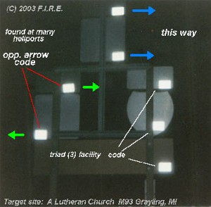 | ||
